Tsunami 10 years later: Is the world better prepared for disaster?
When the Indian Ocean tsunami struck on Dec. 26, 2004, no one saw the massive waves coming.
Authorities in Indonesia, where a 9.1 magnitude quake sparked the tsunami, weren't able to send out an alert because the country's sensor system had been hit by lightning. Thai officials did send a warning, but only after the first deadly wave hit. And in India, word of the disaster went to the wrong official.
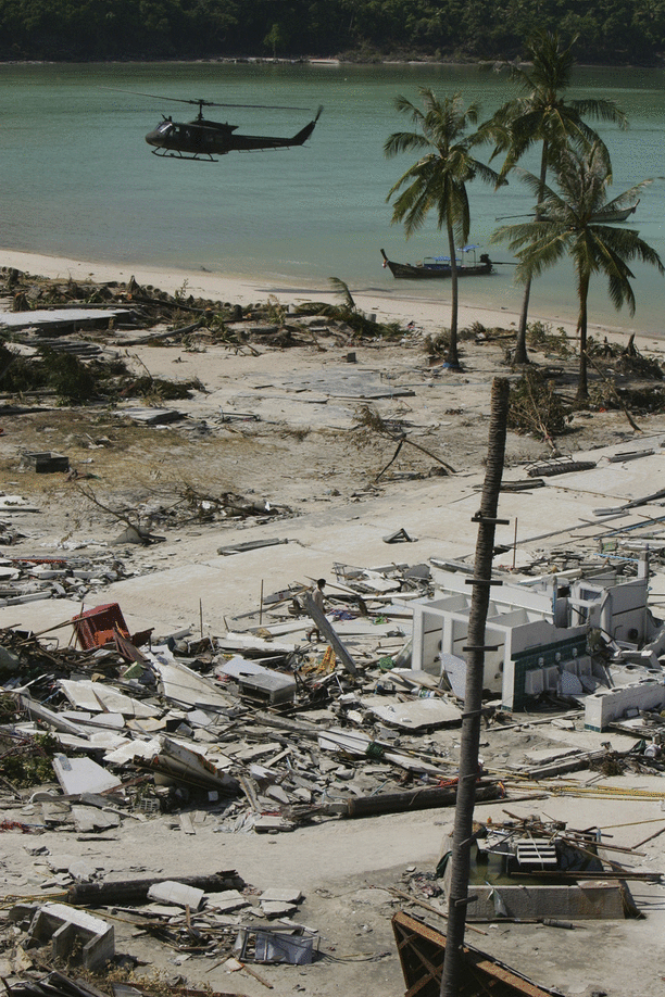
These mishaps were among a series of errors that contributed to the Indian Ocean tsunami becoming one of world's worst natural disasters, with almost 240,000 dead and more than a million homeless in 14 countries. Hardest hit was Indonesia, where about one out of every four people in parts of Aceh province perished in the face of 100-foot waves that destroyed dozens of remote, coastal communities.
And even if all the reporting systems had worked, there was no way to predict who was going to get hit and when, or how bad it would be.
"What the 2004 event showed very clearly was that there was nothing in the Indian Ocean, nothing whatsoever in terms of technology or people's awareness or infrastructure preparation," Kerry Sieh, the director of the Earth Observatory of Singapore who has spent nearly two decades studying earthquakes and tsunamis in the region, told CBS News.
Ten years on, the region that stretches from Africa to Australia is much better prepared. A network of seismometers, tidal gauges and ocean buoys deployed after the disaster can detect the undersea tremors that generate tsunamis. Improved communication networks ensure warnings reach governments across the globe.
Yet all this technology has its limits. While this data surely helps countries hours away from an approaching tsunami, there is still is very little that satellites and around-the-clock command centers can do for hundreds of thousands of people living in vulnerable coastal communities.
"There are still tremendous gaps in people being secure from tsunamis in the Indian Ocean," said Sieh, who has done extensive work in Padang, an Indonesian town which he and his team project will be hit by a big tsunami before 2040. If that happens, he estimates that only 10 percent of the 400,000 people living or working where the wave would come ashore would survive.
"It's relatively easy to put in high-tech sensors that can detect a tsunami in open ocean soon after it's formed," he said. What is difficult is preparing infrastructure for the onslaught and educating people on how to react and get to safety.
In the wake of the disaster
Within days of the 2004 tsunami, governments across Asia began examining why they were caught unawares by such a massive event and what they could do to make their communities safer. Many turned their attention to building a warning system similar to the one that was set up in the 1960s and covering much of the Pacific Ocean, where tsunamis are much more common.
After months of finger pointing, political jockeying and several technical glitches, the Indian Ocean Tsunami Warning and Mitigation System was opened in 2007 at a cost of more than $130 million.
"I would say [the 2004 tsunami] was a seminal event in terms of establishing those tsunami warning systems," Mike Angove, the tsunami program branch manager at the National Oceanic and Atmospheric Administration.
"It certainly caused the international community at the U.N.-level to look across the board and determine where we were insufficient in terms of warning systems," he said. "The Indian Ocean was obvious because we didn't have anything for this event."
Featuring a network of 148 seismometers to detect undersea earthquakes as well as 101 coastal sea level gauges and nine ocean tsunameters to detect tsunami waves, the network transmits data to three warning centers in Indonesia, Australia and India, as well as 28 member states which are part of the system. The 10-member Association of Southeast Asian Nations also opened a center in 2011 to monitor all disasters across the region and coordinate humanitarian responses.
Upwards of $500 million overall has been spent by countries in the region on tsunami systems, according to Tony Elliott, who heads the Intergovernmental Coordination Group for the Indian Ocean Tsunami Warning and Mitigation System.
Indonesia, through funding and support from Germany, has one of the most advanced systems in the region. The system, according to GFZ German Research Centre for Geosciences, opened in 2011 and features 300 measuring stations. Taking data from seismometers, GPS stations and coastal tide gauges, the system boasts the capability to issue alerts five minutes after an earthquake is detected.
Similar tsunami warning systems have since been set up in other parts of the world, including one in the Caribbean and one in the Mediterranean.
These state-of-the art systems benefit from several scientific advancements that make forecasts more precise as well as a greater scientific understanding of just how tsunamis form and spread across the vast oceans.
Bruce Jaffe, a research oceanographer with the US Geological Survey Pacific Science Center, said predictions in the past largely depended on taking the magnitude of an earthquake and guessing whether it would lead to a tsunami and how big one might be.
"It wasn't very accurate," he said. "You knew if there was a magnitude 9 earthquake, there would be a large tsunami, but you didn't know how large. If it was a magnitude 8, there might be a large tsunami or not. Magnitude 7 probably not but, believe it or not, some magnitude 7 earthquakes create large tsunamis."
Now, forecasters also use data from DART buoys, which are the first line of defense in the deep ocean. After the seismometers on the bottom sense a quake, these buoys are able to detect pressure changes which signal a tsunami. There were none before the 2004 tsunami. Now, there are 60, mostly dotted around the Pacific rim. Three successfully detected the 2011 Japan tsunami.
With these buoys, Vasily Titov, the director of the NOAA Center for Tsunami Research, said researchers can now make accurate forecasts within an hour of receiving that data. In the future, they will be able to cut that down to just 15 minutes.
What does that mean? "It means...we can predict [a tsunami] in time for the people to evacuate," Titov said.
Technology only goes so far
The new system is ideal for countries which have several hours to prepare for the onslaught.
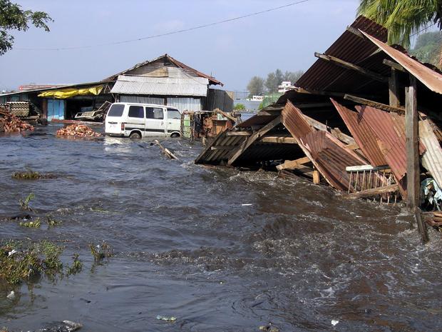
But the alerts are of little use for coastal residents living on the doorsteps of subduction zones -- places where two tectonic plates collide, hotbeds of seismic activity. They can be found around the Pacific Ocean, offshore of Washington, Canada, Alaska, Russia, Japan and Indonesia. Both the 2004 tsunami and the 2011 Japanese tsunami occurred on or near subduction zones, in what is known as "the ring of fire."
In the former, the first waves came ashore in the historic Indonesian port town of Calang only nine minutes after the earth stopped shaking. It almost completely wiped out the town and surrounding villages, leaving just one home and part of a district courthouse standing. About two-thirds of the 12,000 residents perished, many washed out to sea, their bodies never recovered.
Three years later in the Solomon Islands, 16-foot-high waves made land five minutes after a quake generated a tsunami that killed 52 and left thousands homeless.
"Even in Japan where they are putting in a fiber optic network with an array of ocean bottom seismometers to get the information about the offshore earthquakes ... there may be not enough time to warn people of tsunami," Jaffe said. "When the tsunami is generated close to shore, it takes time for the information to be analyzed and for the message to go out to disaster preparedness personnel, for the authorities in the cities to start the evacuations."
Sieh agreed, saying that governments in places like Indonesia might be better off spending less on sensors and putting greater resources into campaigns to educate coastal residents about how to respond when a tsunami hits. He has advocated more funding for such things as evacuation routes, high-rise shelters and efforts to relocate citizens from vulnerable areas.
Pointing to Padang and nearby coastal communities, Sieh said, "you would not save that many lives" if an alert went out five or 10 minutes after a tsunami was generated offshore. Sieh and his team have worked to raise awareness there, but have not seen local authorities make the issue a priority. Two high-rise shelters that would save 4,000 residents each have yet to be built, he said.
"There has not been adequate education ... and there has not been any significant infrastructural improvements in that place," Sieh said. "That goes for other places in the world."
The misinformation was on display in 2012, according to Nature, when an 8.6 magnitude earthquake hit off the coast of Aceh. Rather than heading to government shelters as disaster experts hoped they would, many people tried to drive away, which created traffic jams. Luckily, the quake only generated a minor tsunami.
Still, it would be wrong to say governments and scientists have forgotten these communities.
There has been extensive research by Jaffe, Sieh and others who are trying to understand which parts of the world are most vulnerable to the next big one. Looking back at the geological record, these researchers examine coral remains, boulders left over from ancient tsunamis, soil sediments and even marine microfossil deposits to develop a timeline of when tsunamis have hit Indonesia, the Pacific West Coast and Japan in the past.
From that, they can project when the next tsunami is likely to hit, as well as the size of the area that might be inundated. The Pacific Northwest, for example, was hit by tsunami back in 1700 and is projected to get hit again on average every 300 years. With that knowledge in hand, scientists can create better maps of where hazards might occur, governments can target resources to these vulnerable areas and community leaders can raise awareness.
"This is definitely more prevalent," Jaffe said of using the geological records to project future tsunamis. "In Japan, they are developing all new tsunami hazard maps. A large part of the requirement for the development of the maps is to document the paleo-tsunamis, the tsunamis that have occurred before written record but are contained in the geologic record."
Japan issued a tsunami warning within three minutes back in 2011, but lacking that historical data, the authorities underestimated the size of the earthquake and thus failed to project the correct size of the tsunami. It initially projected the tsunami would be 3 to 6 meters, but it turned out to be two or three times higher.
Making communities tsunami-proof
There have also been huge efforts at making communities more resilient, as part of the $14 billion spent on post-tsunami reconstruction over the last 10 years. Along with nearly 250,000 new homes -- many of them earthquake-proof -- built across the region, many towns and villages now have cellphone coverage allowing them to receive mobile alerts. Asphalt roads have replaced dirt paths and signs advising of tsunami zones and evacuation routes are as commonplace as telephone poles in many coastal communities.
And where alert systems don't reach down to the local level, governments are finding innovative ways to get the word out.
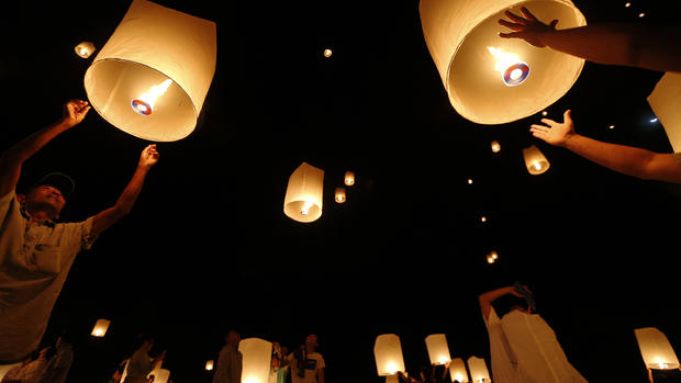
Indonesia has used mosque loudspeakers, normally used for the call to prayer, to send out tsunami alerts. Bangladesh has turned to bullhorns to warn tourists and fishermen, and a Sieh's center in Singapore has designed a tablet game aimed at making the tsunami lessons a little more fun to learn.
The game, called Earth Girl 2 in recognition of the fact that so many girls and women died during the tsunami, was launched this month and can be downloaded from iTunes. It is a role-playing game in which the choices player make -- building roads, creating evacuation routes, educating people about tsunami risks -- determine how many villagers survive a tsunami. There are numerous scenarios, from rural fishing villages to crowded urban centers.
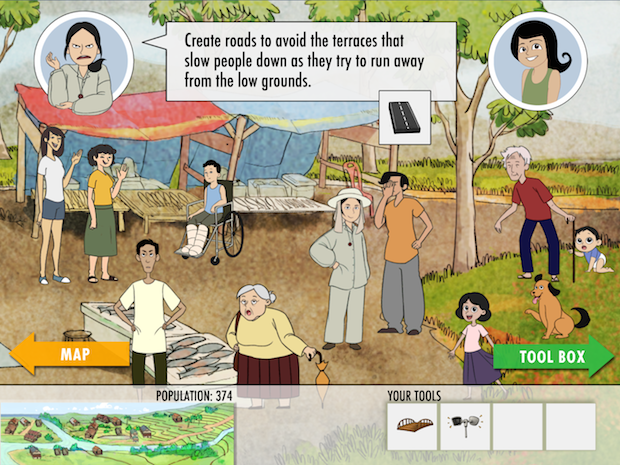
"The problem with a lot of materials about the tsunami is that they are about reading and analyzing. A lot of people don't get into that, period," said Isaac Kerlow, the game designer and artist-in-residence at the Earth Observatory in Singapore. "If you go into a village and get them a brochure explaining how a tsunami happened, that won't connect with them. But if you engage children with a game where they have to play a role of saving a community and empathizing with the characters, then it becomes a part of their little experience."
Listening to nature, saving lives
Maybe most important, there is a growing push to teach communities to heed the of nature -- something many ignored during the 2004 tsunami.
"When you have a tsunami near you, you may get no warning. You may get the wave," Angove said of importance of making citizens aware of "natural warning signals."
"We are not making everyone science experts or tsunami experts," he said. "But we can prepare people to understand natural cues, what they might mean, and take actions which are going to make the difference in them surviving or not."
Few in Indonesia understood that the strong quake they felt or the way the ocean receded from the beach meant a tsunami was on its way. In fact, many reportedly ran out to the exposed corals to collect fish, only to be killed when the waters came rushing back. Many also had no idea where to flee, since they had never witnessed a tsunami. They were unable to evade the waves, which traveled as fast as a jetliner and washed several miles inland.
Nowhere are these lessons heeded more than in Calang. Every survivor has a story to tell and they pass those lessons onto to their children. Along with new homes and markets, this dusty trading town also has a two-story tsunami shelter that is the tallest structure in town. The evacuation routes are clearly marked and remnants of several buildings and even a crumpled car serve as reminders of the tsunami's power.
And every time the coastal town is hit by a dangerous storm, residents said they take no chances. They grab their children and head to the forested mountain just behind the town that served as their homes for weeks after the 2004 tsunami.